Wednesday, January 21, 2009

One Foggy Afternoon Walk: Stanley Park

The weather on the west coast has been abnormal, to say the least. With December snow building a large snow pack mixed with a pineapple express, weather term not Seth Rogan, melting the snow and adding alot of rain has made for an interesting end/ beginning to 2008/2009. All the more strange were the temperature inversions that lasted for just over half a week that saw most of metro Vancouver inundated in fog and cool temperatures, but the mountains were reaching temperatures of 25 Celsius. So with the trapped cool air my wife and I decided to head out to Stanley Park and walk along the sea wall. Our trek took up 4.5km from the beginning of the sea wall in Coal Harbour to the Lions Gate Bridge. The sea wall was closed at the Lions Gate Bridge due to unstable slope faces above the sea wall along with some damage to the sea wall from the weather. These are my first shots of the New Year enjoy.


Coal Harbour:


Sea Wall: Across from the Canadian Naval Reserves Building:
Sarah's Scarf:
Fading Trees:
Lady in a Wetsuit, according to the placard:
Lions Gate Bridge:
Moss, Lichen, Foliage etc...

Thursday, November 13, 2008

Maps

Thinking of how we depend on GPS, GIS platform maps such as Google maps, map quest nothing beats tangible map in my books. We can depend on technology all we want but it can't be the final option. Technology has been know to need batteries, breakdown give wrong directions, yeah I'm speaking to you map quest and google, the tangible hard copy map is still relevant.

(my topo map)


My self I have a fascination with maps because it is a representation of how we see the world. So much information can be presented the basic political maps of boundaries and cities, road map, topographic maps show elevation.

(my topo map)
Maps are a form of communication that has been used from very early times whether indigenous people who use animal bone piles on the prairies to say this is a good hunting spot, to propaganda maps of Hitler invading all of Europe and the World.

www.newberry.org/smith/slidesets/vs1.html


So don't depend on technology, use it but balance it out with a hard copy tangible map it save you a couple of bucks as you have no need to throw out your GPS after the millionth "turn left....recalculating route....turn right.....recalculating route."


Tuesday, November 11, 2008

White Rock: Rock Stacking

My wife and I were sitting on the patio at a White Rock eatery and out of the corner of my eye I noticed something odd on the landscape. The oddity was making me curious through out the course of dinner. I remember coming to the conclusion that it was a sand castles but as we walked away from the establishment towards the oddity in the distance my curiosity peaked again as there was no sand near the Art Gallery building and low and behold there was a man stacking rocks calmly and peacefully as a crowd of people had surrounded him. So following is what my wife and I saw, very impressive at least to us.


Unfazed by the crowd:


Monday, November 10, 2008

Manning Park (Skyline)


My friend I took off early in the morning hike for five fun filled hours. The trail that we tackled is called Skyline it starts from Strawberry flats near the ski hill and takes you to the junction of skyline1 and skyline2. Skyline1 starts from the east from spruce bay. Skyline2 continues west from the junction and takes you down into the Skagit Valley. The elevation gain from Strawberry flats to the junction is roughly 1500ft or 450m over 5km with a grade of 9%. So not super steep but a good work out to the junction.


The map below shows the trail as a black dashed line. The junction as I saw it seemed to be more to the west as the red line would indicate, some nice heads up digitizing eh eh. There are five points on the map and they coincide with pictures.


The trail takes you from heavy forest up through sub alpine and alpine areas as the treeline thins out. There are some good examples of glacial features left from the last glacial period. The main features that I observed were U-shaped valley's and a possible Nunatuk with cirques, arretes, scree and talus slopes.

(Point 2)
This is the view from the junction. In the distance you will see a defining mountain in the distance. That is Mount Hozameen which is located South of the 49th. The Lake in the bottom of the picture is Thunder Lake the most westerly of the thunder lake chain.

So here is a closer view of Mount Hozameen. There are some defining glacial features that can be observed. First is the Nunatuk which is located to the right side of the picture (snowy side, above the tree). A nunatuk is pyramid point in which was not eroded because it was higher than the ice. So how high was the ice you ask... about 2km's all the other peaks in the area are rounded due to glacial erosion. Another interesting fact is that Mount Hozameen seems, from a distance to be made of igneous which means that it is more resistant to erosion therefore the sharp features we created as the weaker material was carried away. There is also a cirque between the two peaks this is where snow accumulates and a glacier is born over many years of accumulation and depletion. There is also an arrete which is a kinfe like ridge at the back wall of the cirque connecting the two peaks.
Here is an example of the rounded peaks these are just under 2000m's so they felt the force of a glacier.
(Point 3-4)
This is a picture of a alpine meadow it was much rewarding to walk on semi flat ground with very little elevation gain after 5km of elevation gain. It is amazing how rejuvenating the flat areas are. In the distance you can see a U-Shaped valley with its steep walls and flat valley floor. Rounded peaks once again sure fire sign of glacial erosion.
I was expecting to see more flowers but I think we were in between seasons for wild flowers. So this hike took place mid July so hike mid June to beginning of July if you want to see wild flowers.
Dying flowers symbolizes depleting stamina of the hike.
Devils Paint brush just coming into season.
This section of the hike was rewarding in a sense that the meadow and breeze but that lasted for about 1.5km then about 1km of narrow scree/ talus slopes of narrow angled trail. Talus for those interested is loose rock. So steep slopes + loose footing * narrow trail + (backpack)*(Camera bag) equals alot of concentration and taking my time (thinking back I should have used my a bigger backpack it would have helped with my balance).


(Point 5)
The summit, sitting at 6550 ft looking across the valley eating lunch there is nothing like it. The wind and sun caressing your skin acts as a pain killer to your sore muscles. There were black flies at the peak that enjoy sweaty flesh, little bugger took a chunk out of palm but I honestly did not care.
I apologize for the stitching job of the panoramic forgive me, my next attempt will be better.

The worst part of the hike is that you have to traverse back eventually so we did. This is the only wildlife we saw. I think it is a grouse nearly stepped on it. We saw other traces of animals such as bear fur, prints and droppings. So be aware of your location and bring some noise makers and use common sense. This is active black, grizzly bear territory.

Josh conquering the said hike
Me and my lame tree impression
This is a beetle kill tree. Manning park has an issue with the pine beetle alot of the trees in the campsites and around the lightening lakes have been taken out.

Manning park has alot to offer outdoors wise hiking, canoeing on the lightening lakes, I also recommend as it is reasonably priced, camping etc... If you think of it in our times of economic strife this could be the perfect staycation as Manning Park is located less than 3hours from Vancouver.

Overall this was great hike got some good shots, I think, had a great sense of accomplishment that no video game could ever give me.

Tuesday, October 14, 2008

Red Bull Soap Box

The Red Bull Soap Box Derby was here but is now gone. The crowds at the event made me wish that I had left earlier to watch man's attempt at art and speed burn down the a hill in Kitsilano. The course contained a hill, for momentum, a jump for air and style points, and cross over section, for hair raising crashes. I also wanted to test out how fast camera could react to said hair raising speed.Ok now that I have talked this event up there were not any crashes that I saw as I was half way up the hill. The Jump acted more as speed bump creating possibly 1-2 inches of air. Although there was on crash that involved a turkey racer which was caused from inexperience at the wheel or the driver possibly eating the shell of the vehicle as the smell of paint fumes and sun surprisingly smell like turkey. In retrospect I do not know if paint fumes and sun smell like turkey it is just a leap with in my imagination.


Here are some photo's of the day's events:

Jon Lenin: living in a submarine.
Celebrity sighting (maybe not): Gordon Campbell shows how he beats the carbon tax
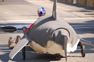
The Shark: this soapbox racer was the well done and carried alot of speed, probably added weight in the nose i.e. Cool Runnings. But there was nothing cool about this race as the Great white shark racer won hands down.
The closest race of the day:

All in all I enjoyed my afternoon in the sun but left feeling that the soapbox races were a hyped up to be something that they were not. Overall my goal was to see how fast my camera could react and found out that about 3 frames a second is not that fast and that timing is everything. But hey it was beautiful afternoon to shoot some photo's which beat sitting inside and watching reruns of the sitcoms of years past.

Tuesday, September 9, 2008

Deep Cove Hike

This hike is perfect for a picnic on a glorious sunny day. The local of the hike is in the sleepy town of Deep Cove which is located East of the City of North Vancouver. The hike is located on the Baden Powell trail. This section of the Baden-Powell trail if continued on will take you on a trek to Lynn Canyon, Which is much longer and,according to the information I have read, is rated between moderate and difficult. The length of the hike that my wife and I did was just over 1km and was a good work out. There were alot of people on the trail a majority running it which was border line insane if you are not in peak physical condition. The trail was well maintained with markers every five steps it seemed. For sections that were too steep for a trail stairs are in place. Below in the graph is a representation of the trail, not completely accurate as I used my GPS for elevation. The elevation gain is about 100m which may not seem like much but 100m of 1100m which works out to a 9-10% grade as generalization of the hike.

Graph: Trail Representation


There are also 5-6 bridges which you cross which I found entertaining, not sure why but I did.The whole hike, to the viewpoint, is in the forest and you are surrounded by massive Douglas Firs
Once you reach the view point you are greeted with a smooth rocky outcrop which has stood up to the erosional forces of water,ice,wind etc.

Photo: Looking South across the Indian Arm towards Burrard Inlet:

Deep grooves,striations, can be seen in the rock out crop which points to glaciation and ice being the main erosional force.

Photo: Striations in the rock out crop.

In the striations and depressions in rock outcrop wind and water have transported and deposited sediment which has allowed for short grass and some other plant life to grow.

Photo: Plant Life

Photo: High above Indian Arm
Overall this was an enjoyable hike not to long but not to short perfect for an afternoon.

Friday, June 27, 2008

Long Exposures

These pictures have been taken within the last year and are my experimentation with open shutter speeds of 30 sec. The photo's start with Lake Osoyoos looking north towards the U.S./Canadian boarder. The next three photo's are from Fort Langley, followed by a series from downtown Vancouver, finally three photo's from my recent trip to Waikiki Hawaii.


Lake Osoyoos from 11:00pm at night


Fort Langley: Bedford Channel Bridge (west):


Fort Langley: Park Bench with some interesting lighting.


Fort Langley: Bedford Channel (east)


The next set of pictures were shot on a cold night -2 (Celsius) about -8 with windchill lots of fun especially when one is not dressed correctly for the elements.


Vancouver: Kits Beach


Vancouver: Stanley Park, Lions Gate Bridge

Vancouver: Burrard Street

If you are wondering how I did this here you go. Long exposure zoomed in to the full extent then when the shutter is open zoom out this will draw the light straight back.

Waikiki: Kuhio beach


Waikiki: Parking Garage


Waikiki: Kalakaua Ave.